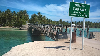
(Still struggling a bit out here at present but getting back into my weekly routine. Yesterday I decided to head down to Friendship Bridge at the far end of South Tarawa for a swim. I had biked there a week before heading back to NZ and was pretty knackered by the time I biked home. It is probably a 46-50km round trip which with the heat and my general lack of bike fitness meant it was going to be a bit of a challenge, at least it was first time I did it. Still it was another beautiful sunny day and I needed to get out and get active.
Friendship bridge is a metal bailey bridge built by the
Americans that spans the causeway/lagoon that links North and South Tarawa. It is at the
far eastern end of the island, two or three kilometres north of the airport.
The channel is about 100 metres wide and the water is quite deep here. It is a
natural passage for the tides that rise and fall each day, draining and filling
the lagoon in an endless cycle that has been conducted for millennia. Due to
the constant flow of water and flushing of the lagoon at this point the lagoon
is safe to swim in, unlike South Tarawa where I live. The lagoon in South
Tarawa has extremely high levels of ecoli bacteria due to pollution and the
amount of raw sewage that floats in it. This of course doesn’t stop the locals
bathing, swimming, fishing and going to the toilet in it, but it sure as hell
keeps the i-Matung from swimming there, as does the large amount of assorted
rubbish either floating in the water or piled up on the shore. It's not exactly
paradise but is yet another consequence of the pressure that the population is
putting on their environment.
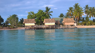
So if I want a swim, I’ve two options. I can go out on the
reef on the seaward side of the island near my house where I surf, or I can
travel east about 23-25kms to Friendship bridge. Although I do enjoy swimming
on the reef near home, it isn’t exactly the most beautiful location, the water
and rocky beach covered in plastic and other assorted debris washed in from all
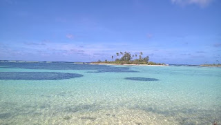
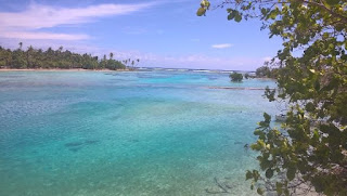
points of the Pacific, whereas the lagoon at Friendship bridge is pretty much
pristine, and a real tropical paradise.
I set out about 10am in the morning, during the heat of
day. It is another perfect day in Kiribati, the sky is a deep blue and not a
cloud to be seen. The prevailing winds are from the east so I have a slight
head wind and more importantly a slight cooling breeze to bike into I as travel
though the various villages and across the causeways on the ribbon of road that
threads its way from atoll to atoll. I am always alert and wary on the road as
biking isn’t exactly safe. Minibuses, the local public transport, travel up and
down, pulling in to pick up passengers and somehow squeeze another person into
the already overloaded transport, then pull out only to repeat the performance
a hundred metres down the road. Passing the minibuses on the narrow main road is
always a bit of a danger, cars coming the other way, often passing each other
as they do so. Dogs, kids wandering out without looking are other constant
hazards, but you get used to that and become an expert at anticipating and avoiding
upcoming obstacles.
 |
| Causeway at Tabario |
 |
| Causeway at Tabario 2 |
Eventually I get to the far end of the island and the round-a-bout at Bonriki that leads to the airport. Only a few kms to go! I bike past the abandoned fish ponds. Mangroves protect the shore on the lagoon side here. At low tide the exposed coral sand is a brilliant white. I push on past the airport, the road runs parallel to the runway and as I bike along it the temperature climbs five or six degrees; it is sheltered from the breeze so there isn’t a breath of wind and it is hot, damn hot! I follow the road around the end of the runway and it soon becomes an unsealed track. I pass more local houses sheltering amidst the trees, here they are much fewer in number than elsewhere on the island.
 |
| Roundabout at Bonriki, one of three in south Tarawa. |
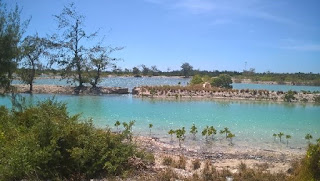 |
| Abandoned fish farms near the airport |
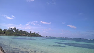
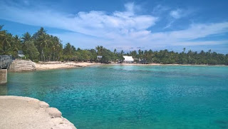
A few minutes more and I’ve made it to my destination. I cross the bridge and lean my bike against a coconut palm and wade out into the warm tropical water for a nice relaxing swim.
 |
| The causeway looking out to the seaward side |
 |
| The Causeway at Friendship bridge |
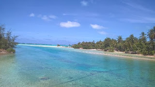 |
| Another view of the causeway looking towards the main lagoon. |
 |
| Made it! |
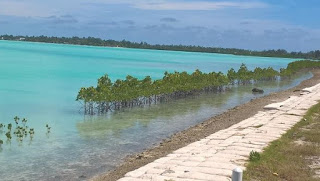 |
| Mangroves growing along causeway near airport. |
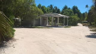 |
| Petrol station Bonriki |
Eventually, it is time to head home. The breeze is on my back but by now I’m tired and getting a little saddle sore. The last fifteen kms are especially hard. I’m not used to biking in this heat, and my legs are getting tired. I stop at one of the local supermarkets for a can of drink for some much needed energy then push off once more.
Recharged I continue back the way I’ve come. Climbing the extra metre to Tarawa’s highest point is always is a highlight, yep three metres above sea level, WOOT! I stop by the causeway at Tabario to watch the fishermen wandering out in the turquoise waters, nothing to do with needing another breather, honest! Then the last few kms beckon. By the time I get back home I'm fairly tired but its been a great day.
Craig


Comments
Post a Comment